
Parcel 41-4N-23-2100-0003-0070
Owners
GADD RILEY GERALD
28358 LAKE HAMPTON RD
HILLIARD, FL 32046
Parcel Summary
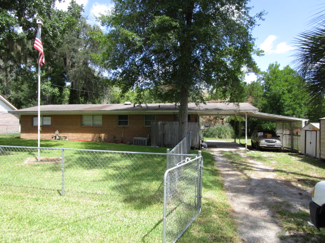
| Situs Address | 28358 LAKE HAMPTON RD |
|---|---|
| Use Code | 0100: SINGLE FAMILY |
| Tax District | 4: Nassau County |
| Acreage | .0000 |
| Section | 41 |
| Township | 4N |
| Range | 23 |
| Subdivision | ST MARYS HIGHLAND PB 5/12 |
| Exemptions | HX: Homestead (196.031(1)(a)) (100%) HB: Homestead Banded (196.031(1)(ab) (100%) |
Short Legal
BLOCK 3 LOT 7EX RW IN OR 106/452
ST MARYS HIGHLANDS PB 5/12-13
Values
| 2025 Preliminary Values | 2024 Certified Values | |
|---|---|---|
| Land Value * | $38,000 | $30,000 |
| (+) Improved Value | $182,304 | $175,331 |
| (=) Market Value | $220,304 | $205,331 |
| (-) Agricultural Classification | $0 | $0 |
| County Assessed Value | $184,782 | $179,574 |
| (=) School Taxable Value *** | $159,782 | $154,574 |
| (=) County Taxable Value | $134,060 | $129,574 |
Document/Transfer/Sales History
| Instrument / Official Record | Date | Q/U | V/I | Sale Price | Ownership |
|---|---|---|---|---|---|
| WD 2521/0581 | 2021-12-13 | Q | Improved | $240,500 | Grantor: ROBERTSON WESLEY A JR & SAMANTHA N Grantee: CREWS DESTINY R & RILEY GERALD GADD (JT/RS) |
| WD 2291/0094 | 2019-07-16 | Q | Improved | $169,000 | Grantor: CONNER MELISSA J Grantee: ROBERTSON WESLEY A JR & SAMATHA N (H&W) |
| WD 2236/1311 | 2018-11-09 | Q | Improved | $139,900 | Grantor: ALLEN-KASSAB STACY L Grantee: CONNER MELISSA J |
| QC 1561/1818 | 2008-04-17 | Q | Improved | $100 | Grantor: KASSAB AKRAM & STACY L ALLEN- Grantee: ALLEN-KASSAB STACY L |
| WD 1317/1885 | 2005-05-16 | Q | Improved | $85,000 | Grantor: MILLER ERNEST P SR & GERALDINE Grantee: ALLEN-KASSAB STACY & AKRAM |
| WD 0853/1148 | 1998-10-26 | Q | Improved | $65,000 | Grantor: RAKES GARY LEE Grantee: MILLER ERNEST SR & GERALDINE |
| WD 0355/0077 | 1982-03-01 | Q | Improved | $47,000 | |
| WD 0226/0302 | 1976-01-01 | Q | Improved | $26,000 |
Buildings
Building # 1, Section # 1, 165256, RESIDENTIAL
| Heated Sq Ft | Year Built | Value |
|---|---|---|
| 1272 | 1967 | $170,933 |
Structural Elements
| Type | Description | Code | Details |
|---|---|---|---|
| EW | Exterior Wall | 19 | COMMON BRK |
| RS | Roof Structure | 03 | GABLE/HIP |
| RC | Roof Cover | 03 | COMP SHNGL |
| IW | Interior Wall | 05 | DRYWALL |
| IF | Interior Flooring | 13 | LVT/LAMNT |
| IF | Interior Flooring | 14 | CARPET |
| AC | Air Conditioning | 03 | CENTRAL |
| HT | Heating Type | 04 | AIR DUCTED |
| BDR | Bedrooms | 3.00 | |
| BTH | Bathrooms | 2.00 | |
| FR | Frame | 03 | MASONRY |
| STR | Stories | 1. | 1. |
| BUD8 | BUD8 Adjustment | 04 | DIST 01 |
Extra Features
Land Lines
Personal Property
None
TRIM Notices
Property Record Cards
Disclaimer
The Nassau County Property Appraiser's Office makes every effort to produce the most accurate information possible. No warranties, expressed or implied, are provided for the data herein, its use or interpretation. The information contained herein is for ad valorem tax assessment purposes only. The Property Appraiser exercises strict auditing procedures to ensure validity of any transaction received and posted by this office but cannot be responsible for errors or omissions in the information received from external sources. Due to the elapsed time between transactions in the marketplace, and the time that those transactions are received from the public and/or other jurisdictions, some transactions will not be reflected.